
Keyword
Earth Science | Biological Classification | Plants
24 record(s)
Type of resources
Topics
Keywords
Contact for the resource
Provided by
Formats
Update frequencies
Status
draft
-

This dataset comprises the phytoplankton abundance and biovolume estimates as part of a broader sampling program carried out at the Southern Ocean Time Series, a facility within the Integrated Marine Observing System (IMOS). The primary focus is sustained observing of ocean properties and processes important to climate, carbon cycling, and ocean productivity. Regular phytoplankton samples are collected at approximately 14 day intervals (exact intervals and seasonal coverage dependent on deployment length). The moorings are serviced annually, at which time the existing moorings are recovered and new moorings are deployed. Water samples from within the surface mixed-layer are collected at pre-programmed intervals using a Remote Access Sampler, in pairs about 1 hour apart. One sample in each pair is preserved for phytoplankton community composition by microscopy, and the other sample is preserved and used for accompanying chemical analysis of nutrients, total dissolved inorganic carbon (DIC) and alkalinity. Each sample is collected from within the surface mixed-layer at 32 m depth (2010 - 2017) or 5 m depth (2018-current) depending on the design of the mooring surface assembly and instrumentation. Typically a maximum of 24 samples are collected over an annual deployment cycle. The samples collected are analysed for: 1. Community composition / abundance (cells/L) 2. calculated biovolume (um3/L). Protocols for the phytoplankton time-series are described in Eriksen et al (2018), and the annual sample reports for each deployment. Data storage and access is planned to be interoperable with other national and international programs through the IMOS Infrastructure. Station metadata can be found through this resource. Data is available freely via the AODN portal: https://portal.aodn.org.au. As the taxonomic resolution of the data has changed over time, due to continual training, it is important that users refer to the change log tables included in your data download. These will provide information on the validity of the taxa, from what date we have been identifying certain taxa etc. Classification fields may be blank depending on the level to which that taxa has been identified, i.e. if only identified to family, genus and species will be blank.
-
This study collects information on intertidal seagrass meadows at Thursday and Horn Island, Torres Strait. Data is collected by scientists and trained students/ community volunteers using the standard Seagrass-Watch protocols (see www.seagrasswatch.org). Three permanently marked sites (50mx 50m) are monitored 3 - times a year. Data is submitted to Seagrass-Watch HQ for QAQC and submission to the main Seagrass-Watch MSAccess database (Northern Fisheries Centre, DPI&F custodians). Summary data and anaylis is presented in quarterly newsletters and available on the web as part of State of teh Environment reporting.
-
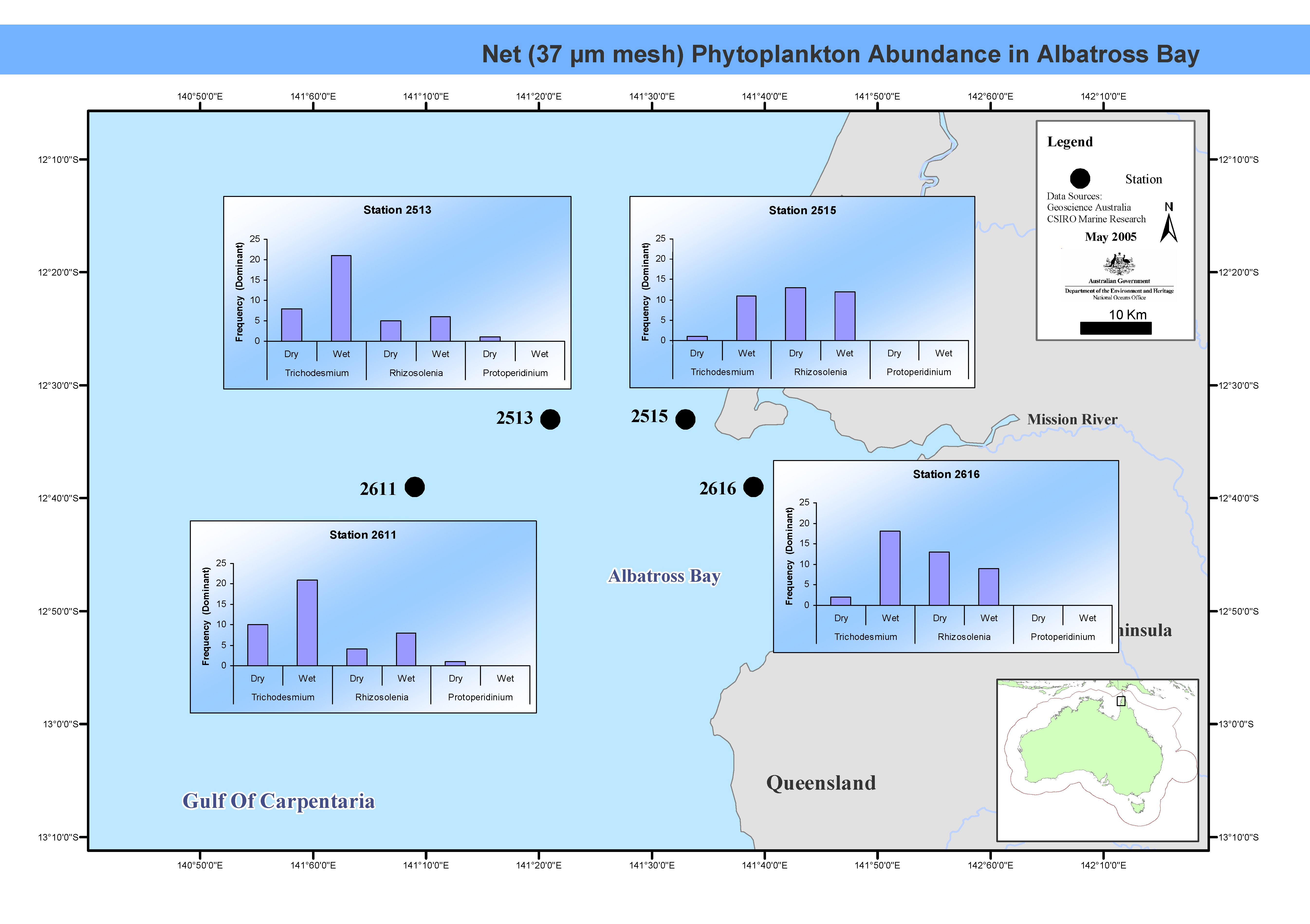
This map shows phytoplankton abundance in Albatross Bay. The biomass and species composition of tropical phytoplankton in Albatross Bay, Gulf of Carpentaria, northern Australia, were examined monthly for six years between March 1986 and April 1992. Phytoplankton taxonomic groups were identified to genus level, and described as dominant, common or rare. This map has been produced by CSIRO for the National Oceans Office, as part of an ongoing commitment to natural resource planning and management through the 'National Marine Bioregionalisation' project.
-
Primary productivity data (growth rates) was obtained for Ecklonia radiata growing in nineteen sites within and just outside Marmion Lagoon. In addition, benthic water temperatures (C) were also collected at each of the sites along with light intensity data (LUX). There were three sample periods of approximately 30 days in December/January, May/June and October/November 2009. Nineteen sites were chosen for the trial. Five sites were selected in deeper water outside the lagoon while eight sites were selected across the mid lagoon. The mid lagoon sites were chosen so as to provide an indication of the growth rates of E. radiata under a wide variety of different light conditions but similar temperature regimes. Six inshore sites were also selected, three of which were in a sheltered position while three were from a more exposed sites. The density of E. radiata at each of the sites was calculated by counting all sporophytes >2 cm in three 1 m2 quadrates, haphazardly placed within an 8 m radius of the stake marking each site. Light and temperature measurements were logged for each site using a Hobo TM light and temperature logger set to log these parameters every 10 minutes.
-
The biomass and species composition of tropical phytoplankton in Albatross Bay, Gulf of Carpentaria, northern Australia, were examined monthly for six years between March 1986 and April 1992. Phytoplankton taxonomic groups were identified to genus level, and described as dominant, common or rare. Refer to the cited publication for detailed methodology.
-
Algal biomass in the Perth region were identified from quadrat surveys , as part of the SRFME research program. The aim of the SRFME Coastal project is to characterize the coastal benthic ecosystems of southwestern WA, with particular focus on benthic reef cosystems, their productivity and dynamics, and the physical, chemical and biological factors driving variability along dominant spatial and temporal scales. To achieve this, we undertook 3-monthly seasonal sampling from 2003 - 2005 at a series of coastal sites situated between Cape Naturaliste in the south and Jurien Bay in the north. Benthic Sampling was integrated with satellite observations of SST, ocean colour and subsurface measurements of other water column properties, as well as sediment biogeochemical sampling. Within this region benthic sampling was nested at Regional (100s km) Local (10s km) and Site (1 km) scales and within each of the regions additional sites were sampled to incorporate site scale variability along cross-shore gradients.
-
Algal biomass in the Rottnest Island region were identified from quadrat surveys , as part of the SRFME research program. The aim of the SRFME Coastal project is to characterize the coastal benthic ecosystems of southwestern WA, with particular focus on benthic reef cosystems, their productivity and dynamics, and the physical, chemical and biological factors driving variability along dominant spatial and temporal scales. To achieve this, we undertook 3-monthly seasonal sampling from 2003 - 2005 at a series of coastal sites situated between Cape Naturaliste in the south and Jurien Bay in the north. Benthic Sampling was integrated with satellite observations of SST, ocean colour and subsurface measurements of other water column properties, as well as sediment biogeochemical sampling. Within this region benthic sampling was nested at Regional (100s km) Local (10s km) and Site (1 km) scales and within each of the regions additional sites were sampled to incorporate site scale variability along cross-shore gradients.
-
Algal biomass in the Jurien Bay region were identified from quadrat surveys as part of the SRFME research program. The aim of the SRFME Coastal project is to characterize the coastal benthic ecosystems of southwestern WA, with particular focus on benthic reef cosystems, their productivity and dynamics, and the physical, chemical and biological factors driving variability along dominant spatial and temporal scales. To achieve this, we undertook 3-monthly seasonal sampling from 2003 - 2005 at a series of coastal sites situated between Cape Naturaliste in the south and Jurien Bay in the north. Benthic Sampling was integrated with satellite observations of SST, ocean colour and subsurface measurements of other water column properties, as well as sediment biogeochemical sampling. Within this region benthic sampling was nested at Regional (100s km) Local (10s km) and Site (1 km) scales and within each of the regions additional sites were sampled to incorporate site scale variability along cross-shore gradients.
-
We used a range of approaches to gain an understanding of spatial and species-related patterns in herbivory in five distinct studies. Using underwater video cameras and Sargassum myriocystum assays, 23 different fish species were observed consuming macroalgae, but seven species (Naso unicornis, Kyphosus sp., K. vaigiensis, Siganus doliatus, Scarus ghobban, S. schlegeli and initial-phase Scarus sp.) together accounted for 95% of the observed bites across five regions. Of these species, three were identified as the most important in consuming macroalgae: N. unicornis, Kyphosus sp. and K. vaigiensis. These results were supported by stable isotope analyses that incorporate nutrients from food sources over far longer periods than those examined using the assay approach. We quantified spatial patterns of macroalgal consumption and food sources across a range of scales. Firstly, across reef habitats separated by hundreds of meters, herbivory was always greatest in the structurally complex coral-dominated outer reef and reef flat habitats, which are also characterised by the highest biomass of herbivorous fish. Secondly, we showed a high degree of variability in grazing rates among regions separated by 100s km in the marine park, with different species responsible for macroalgal removal among those regions. Either N. unicornis or Kyphosus spp. were responsible for the majority of the grazing. Thirdly, we showed variability in the importance of different food sources across both habitats and regions for some consumers (e.g. Siganus spp.) but consistency for other species (e.g. Naso unicornis, Kyphosus spp.), which is likely to reflect shifts in food source availability or feeding preferences. Lastly, we found strong transcontinental differences between Keppel Islands in the Great Barrier Reef (GBR) on the east coast of Australia and Ningaloo Reef in both the diversity of the species observed feeding and on the species composition of the roving herbivorous fish community. In Ningaloo Reef, 23 species were observed biting on Sargassum, compared with just 8 in the Keppel Islands. Sargassum consumption in the Keppel Islands was dominated by a small number of species and supports the identification of Naso unicornis as a key browser species. The larger number of species feeding on macroalgae in Ningaloo Reef suggests that there may be higher functional redundancy among macroalgal consumers in this system. We also characterised the benthic community dynamics of the reef-flat and lagoon habitats to identify seasonal patterns and we experimentally determined the importance of herbivory on algae recruitment in these two habitats. Differences among habitats in algal biomass were strongly influenced by season. Lagoon habitats only had higher biomass than reef-flat habitats during part of the year (late summer/ early autumn). Herbivory had an equally strong effect on the community composition of algal recruits in the lagoon and reef flat habitats, despite the reef flat hosting a herbivorous fish community that was an order of magnitude greater in terms of biomass than the lagoon, which is characterised by younger and smaller fish (e.g. Scarus initial phase).
-
Algal biomass in the Geographe Bay region were identified from quadrat surveys on Cape Naturaliste and Cape Leauwin reefs, as part of the SRFME research program. The aim of the SRFME Coastal project is to characterize the coastal benthic ecosystems of southwestern WA, with particular focus on benthic reef cosystems, their productivity and dynamics, and the physical, chemical and biological factors driving variability along dominant spatial and temporal scales. To achieve this, we undertook 3-monthly seasonal sampling from 2003 - 2005 at a series of coastal sites situated between Cape Naturaliste in the south and Jurien Bay in the north. Benthic Sampling was integrated with satellite observations of SST, ocean colour and subsurface measurements of other water column properties, as well as sediment biogeochemical sampling. Within this region benthic sampling was nested at Regional (100s km) Local (10s km) and Site (1 km) scales and within each of the regions additional sites were sampled to incorporate site scale variability along cross-shore gradients.